|
Kefalonia Touring
 Touring Kefalonia takes a bit of time, as the island is so large, and you are so often tempted along the way to stop for a swim at its many beautiful beaches! Using the capital, Argostoli, as your starting point, there are many interesting things to see in and near the town. The Archaeological Museum is always a good place to start; finds are included from all over the island and covering the most significant periods, plus there is a room entirely devoted to the Mycenaean period. Also in town is an interesting Folklore Museum, which is situated downstairs from the library. At the peninsular tip of the capital are the Katavothres (pits or swallow holes), where seawater floods into underground tunnels and is carried across the island to two lakes near Sami. From the town of Argostoli, there is a connecting bridge eastward to the largest or main part of the island. The bridge, called Drapanos, was built by the British in the early 1800s. From here, there is a direct road to Sami, the second port on the east coast. On your way there, and if you’re interested in seeing the view from the top of Mt. Enos, there is a turnoff after about 15 kilometers. The area has been declared a national park for the rare fir trees that grow there (and only on Kefalonia!), and the views from there are better than outstanding! Touring Kefalonia takes a bit of time, as the island is so large, and you are so often tempted along the way to stop for a swim at its many beautiful beaches! Using the capital, Argostoli, as your starting point, there are many interesting things to see in and near the town. The Archaeological Museum is always a good place to start; finds are included from all over the island and covering the most significant periods, plus there is a room entirely devoted to the Mycenaean period. Also in town is an interesting Folklore Museum, which is situated downstairs from the library. At the peninsular tip of the capital are the Katavothres (pits or swallow holes), where seawater floods into underground tunnels and is carried across the island to two lakes near Sami. From the town of Argostoli, there is a connecting bridge eastward to the largest or main part of the island. The bridge, called Drapanos, was built by the British in the early 1800s. From here, there is a direct road to Sami, the second port on the east coast. On your way there, and if you’re interested in seeing the view from the top of Mt. Enos, there is a turnoff after about 15 kilometers. The area has been declared a national park for the rare fir trees that grow there (and only on Kefalonia!), and the views from there are better than outstanding!
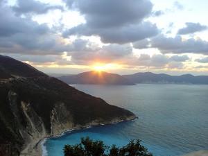
Sami is the second port of the island and most of the ferry traffic arrives here. It has a well-developed tourist infrastructure, a pretty waterfront with tavernas and bars, and lies very near the ruins of ancient Sami. From Sami, you can visit the caves of Drogarati, a land cave with superb stalactites and stalagmites, and Melissani, a sea cave of particular beauty. It is here that its lake is fed by the Katavothres near Argostoli. From Sami, you can work your way north to Ag. Efthimia, which is a modern yacht harbor and secondary port for ferries across to Ithaca. Driving to nearly the tip of the island will bring you to Fiskardo, the only town on the island to have survived the 1953 earthquake. It has some of the original Venetian houses that were prevalent on the island before they were destroyed by the quake. It has a lovely atmosphere, surrounded by pine and cypress trees, with small fishing boats bobbing in the water, two lighthouses, and it has a beautiful view across to Ithaca. Working your way back south and heading toward Argostoli, you’ll come to the lovely village of Assos, certainly one of the most picturesque on the island, with the ruins of a Venetian castle at the top. Further south is the most talked about beach on the island, Myrtos, which we’ll mention in more detail further on.
Continuing south, you can connect to the Paliki peninsula, home to the second largest town on the island, Lixouri. The town was totally destroyed by the earthquake and rebuilt afterward, and has some fine architecture, an old mansion housing the library, and the ruins of ancient Paliki nearby at the site of Palaeokastro. A drive through the peninsula will bring you to several very attractive villages and the old monastery of Kipouraion, situated in one of the most scenic spots on the island, overlooking sheer, pure white cliffs. From Lixouri, you can take a ferry back across to Argostoli and begin to explore the southern region of the island. Heading for Poros on the east coast, you’ll first come to the Castle of Ai. Georgios, which overlooks the entire plain and was the medieval capital of the island. The village of Markopoulo, which lies about 17 kilometers from Argostoli, has a strange celebration during the second week of August each year, with the appearance of many small snakes (reincarnated nuns from the old convent!) which are said to bring good luck! If you continue on this road, it will lead you to Poros, a well-developed tourist resort and port for ferries to the Peloponnese.
For beaches, we can start with Poros and work back toward the south. The Poros beaches are a mix of sand and pebble, but the area is very well developed for tourism. Right at the southeast point of the island is Skala, a beautiful beach of several kilometers, featuring good accommodation, restaurants, and incredibly clear water for swimming. Nearby is an excavated Roman Villa with mosaics that is possible to explore. Moving westward, there is another excellent beach near Skala called Kato Kateleios, the island’s breeding ground for the loggerhead turtle. Further west, you have the pretty areas of Lourdhata and Trapezaki. Skirting around the airport and working your way up to Argostoli, there are two lovely beaches, Platys Yialos first, then Makry Yialos.
On the Paliki Peninsula, there are three excellent beaches south of Lixouri, all sand and backed by low cliffs. The first is Lipedha, followed by Megas Lakos, and then Xi. To the north of the peninsula is the fabulous beach of Petani. If you cut back across to the main part of the island above Argostoli, then work your way north toward Assos, you come to the beach of Myrtos. The beach itself is a mix of sand and pebbles, and is very beautiful in its own right, but the view overlooking the beach from above, or from down on the beach looking upward, is one of the finest you’ll find anywhere in Greece. Further on and around Fiscardo are two lovely pebble beaches, Emblisi and Fokis. Further south, before and after Sami, you will find several beaches worth noting. The first is the long stretch of sandy beach that surrounds the bay, and further northeast is the pretty pebble beach of Andisami. It should be noted that we’ve only mentioned the most well known beaches of the island, but if you’re planning on visiting this outstanding island, rest assured that there are many more just waiting to be discovered!
|
|
|
|